 Filter: Categories of Wisconsin Historical Images
Filter: FORMAT_NUMBER_ORG of PH Series 1955
Filter: Categories of Wisconsin Historical Images
Filter: FORMAT_NUMBER_ORG of PH Series 1955

| Date: | 1928 |
|---|---|
| Description: | T. N19 R. 4W about section 19, McPeak farm. A 50 foot deep ravine is seen rapidly eating its way toward farm buildings. |

| Date: | 1932 |
|---|---|
| Description: | A man and a woman standing next to a tent in the Wisconsin Land Economic Inventory field camp. |
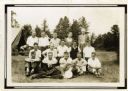
| Date: | 1932 |
|---|---|
| Description: | Group portrait of a group of Wisconsin Land Economic Inventory workers. John Bordner is in the center of the top row. Stanta Bordner is beside him. Uppe... |
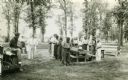
| Date: | 1937 |
|---|---|
| Description: | Probably Native Americans receiving instructions on compass use for Wisconsin Land Economic Inventory. |
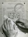
| Date: | |
|---|---|
| Description: | Person's hands, one with with wedding ring on left hand, using a ruler, pencil, and protractor to draw a land cover map for Wisconsin Land Economic Invento... |
| Date: | 04 23 1937 |
|---|---|
| Description: | Sand barrens being used for poor crops. Note on back of print reads: "This should be in timber." |
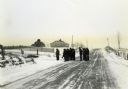
| Date: | |
|---|---|
| Description: | Wisconsin Land Economic Inventory mapping crew starting out in the snow for instruction. |

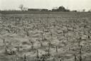
| Date: | 10 29 1937 |
|---|---|
| Description: | Two boys standing among stumps in northern Wisocnsin cutover land. T. 34N R. 9E on Highway 17. Trees cut approximately 40 years before photograph was taken... |
If you didn't find the material you searched for, our Library Reference Staff can help.
Call our reference desk at 608-264-6535 or email us at: